After staying put for three consecutive years, the triple-dip La Niña conditions finally came to an end officially. The oceanic temperatures have been increasing consistently indicating the return of El Niño conditions.
An El Niño condition occurs when surface water in the equatorial Pacific becomes warmer than average and east winds blow weaker than normal. The opposite condition is called La Niña.
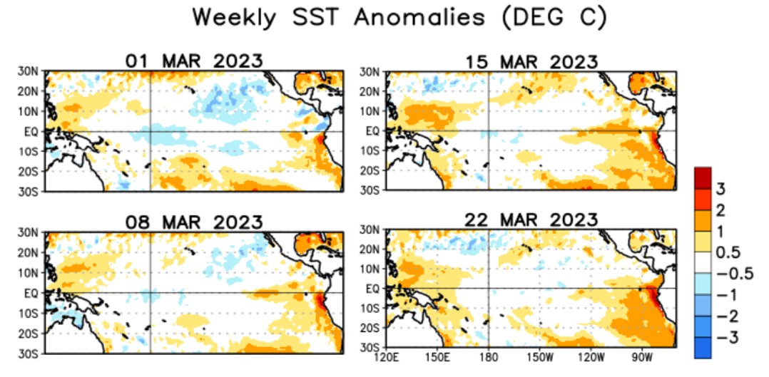
Negative sea surface temperatures (SST) anomalies have gradually weakened across most of the equatorial Pacific Ocean since at least December 2022. Since late January 2023, positive SST anomalies have strengthened in the eastern equatorial Pacific and have shifted westward.
Negative SST temperatures indicate that the ocean is cooler than average, while positive temperatures indicate that the ocean is warmer than average. Tracking sea surface anomalies helps scientists quickly identify the development of La Niña and El Niño, respectively.
During the last 4 weeks, positive SST anomalies strengthened in the eastern Pacific and expanded westward. Negative SST anomalies dissipated in the central Pacific Ocean.

There has been a constant rise in the SSTs during the last few weeks, particularly in the Nino index of 3.4, which is the area of concern for the Indian region. The Nino 3.4 region is a deciding factor for declaring El Niño. Here is a look at the recent Nino Index (in °C):

El Niño is declared when the Oceanic Niño Index (ONI) value, which is defined as the three-month running-mean SST departures in the Niño 3.4 region, is greater than or equal to +0.5ºC for a period of at least 5 consecutive overlapping 3-month seasons.
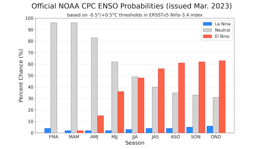
At present, the El Niño- Southern Oscillation (ENSO) has turned neutral, which is likely to persist through the Northern Hemisphere early summer 2023. Thereafter, a transition to El Niño is favoured by July-September 2023, with chances of El Niño increasing through the fall.

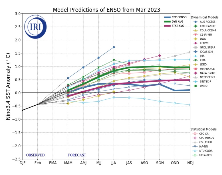
By May-July 2023, the dynamic models suggest a potential return to El Niño, while the statistical models indicate the continuation of ENSO-neutral into the Northern Hemisphere summer, before warming up to borderline El Niño conditions in the late summer or fall 2023.

The Bureau of Meteorology (BOM) -Australia and Japan Agency for Marine-Earth Science and Technology (JAMSTEC) have already issued El Niño ‘WATCH’ in their latest outlook. The National Oceanic and Atmospheric Administration (NOAA), USA is likely to follow soon. The Watch bulletin is issued when there is a 50% chance of El Niño conditions. While El Niño WATCH is not a guarantee that it will occur, but it is an indication that some of the typical precursors are currently being observed.
El Niño and La Niña events (collectively referred to as the El Niño–Southern Oscillation or ENSO) are driven by changes in the equatorial Pacific Ocean. During El Niño, sea surface temperatures in the central and eastern Pacific Ocean become warmer than average, while La Niña is characterised by cooler than average sea surface temperatures in the same regions.
Two-way relation between Global warming and El Niño
Recent research indicates that the frequency of extreme El Niño events increases linearly with the global mean temperature, and that the number of such events might double (one event every ten years) under 1.5°C of global warming. This pattern is projected to persist for a century after stabilisation at 1.5°C, thereby challenging the limits to adaptation, and thus indicates high risk even at the 1.5°C threshold. Changes to the frequency of extreme El Niño and La Niña events may also increase the frequency of droughts and floods over several regions of the globe such as the South Pacific Islands. In the South Pacific Islands during and following an El Niño, the global mean surface temperature increases as the ocean transfers heat to the atmosphere. Warming of the waters, such as during El Niño, eliminates the cloud deck and leads to further sea surface warming through solar radiation.
“We do get a mini-global warming during an El Niño since the warm water spreading across the tropical Pacific releases massive amounts of heat from the ocean to the atmosphere. Headlines are already blaring that an El Niño this year could push global warming to rise past the 1.5C level. Unfortunately, it is not clear if that temporary blip will produce anything dramatic beyond the extremes we are already experiencing. El Niño will of course bring its usual global perturbations to the cyclones, monsoon, wildfires, dust storms, and so on,” said Raghu Murtugudde, Visiting Professor, Earth System Scientist at IITB and Emeritus Professor at University of Maryland.
There is a negative correlation between ENSO and the Indian summer monsoon (weak monsoon arising from El Niño events). It causes a change in the precipitation pattern and has a strong impact on glacier-fed rivers. Ice cores from the Himalaya indicate that snow accumulation in the region is sensitive to the changes in the South Asian Monsoon.
El Niño is a very complex phenomena to explain and is quite famous for its notorious behaviour. Particularly for sub-tropical regions that bear the maximum impact of this phenomena, invariably linked with below normal rainfall during the Southwest Monsoon.
The article was published at Carbon Impacts.
About The Author
You may also like
Cyclone Michuang triggers flash flooding along India’s southern coast; 5 lives lost so far
Swinging in the rain: India needs to redefine what a “normal” monsoon looks like
Global ocean warming and rising, growing more acidic: Report
Billions at risk of heat and humidity exposure beyond human levels: Report
Climate change threatening almost all SDGs, only 15% on track: UN Report


