Meteorologists predict another spell of heavy to very heavy rain and thundershowers on November 10-11
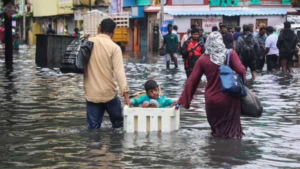
Chennai surpassed its monthly average rainfall in the first week of November itself. Nungambakkam Observatory recorded a total of 464mm of rainfall from November 1-9, while Minambakkam reported 369mm of rain, as against the normal average of 374mm. Peninsular India, and the city, is now headed for another spell of heavy rainfall as the northeast monsoon gains momentum, according to the latest forecast by the India Meteorological Department (IMD).
After a brief respite over the last two days, the IMD has warned that a well-marked low-pressure zone over southwestern Bay of Bengal looks likely to bring a fresh spell of rain to the southeastern coast. The low-pressure zone is expected to concentrate into a depression which will bring heavy rainfall to several parts of Tamil Nadu and coastal Andhra Pradesh and Rayalseema over the next four days.

Chennai’s wet spell so far
The 215mm of rainfall recorded on November 7 is so far the second-highest rainfall recorded in the span of 24 hours in the past decade for Chennai—the highest being 246.5mm recorded on November 16, 2015. The all-time high record stands at 452.4mm, recorded on November 25, 1976.

Chennai has been recording good rainfall since the beginning of the Northeast monsoon. The state Capital recorded 48% excess rain—593.4 mm against the normal of 399.7 mm—from October 1 to November 9. Tamil Nadu, too, recorded 45% excess rain—361mm against the normal of 248.3mm—during the same time span.
A reason for heavy rainfall in the region is the cyclonic circulation over southeast Bay of Bengal and adjoining areas, which has strengthened into a low-pressure area. Atmospheric conditions are favourable for the system to further intensify into a depression over Southwest & adjoining Southeast Bay of Bengal by November 11. Weather models are indicating that this is likely to move west–northwestwards and reach the north Tamil Nadu coast early on November 11. Heavy rains are likely to continue thereafter on November 12, and the likely depression may move inland, meteorologists said. The coastal areas of Tamil Nadu and Andhra Pradesh that are likely to be impacted include:
Climate change to blame?
Although meteorologists have ruled out a direct link between the heavy rainfall in Chennai and climate change, the latter’s contribution cannot be negated completely. Here are a few changes that have been triggered by climate change and have altered weather patterns, too.
● Rise in global temperatures has increased the frequency of heavy rains
● The Indian Ocean is warming at a faster rate, with sea-surface temperatures (SST) soaring above average. Meteorologists said 26.5°C is the threshold value, past which the conditions are very favourable for cyclogenesis or rapid intensification of any weather system.
● Rise in sea surface temperatures has led to a stronger storm surge. Storm surge is an abnormal rise of water generated by a storm, over and above the astronomical tide
● Increase in the life-span of low-pressure areas over the land is causing more damage.
● Global warming has increased sea level rise by 10%-15% across the Indian seas. This coupled with heavy rainfall can amplify the damage.
According to meteorologists, the Northeast monsoon would continue to be active for the next couple of days. The reason could be attributed to all key oceanic parameters coming together, setting the right atmospheric conditions for the formation of back-to-back weather systems in the Indian seas, particularly in the Bay of Bengal. All the 3 oceanic parameters—La Nina, Indian Ocean Dipole (IOD) and MJO (Madden–Julian oscillation)—are in favorable positions at present.
About The Author
You may also like
Weather office alert on severe heat waves and heavy rainfall in parts of India
Climate goals overestimate forests’ carbon absorption capacity: Study
More heatwaves and hotter summer: IMD summer forecast
Between urgency and inclusion: Why the IPCC can’t agree on AR7’s timeline
Severe heat waves hit several states ‘unusually early’